Monday, April 30, 2012

Trail Discovery for Kids: Hazel Mountain Trail, SNP


Waterfall and swimming hole

May 2012 Highlighted Hike
Hazel Mountain Trail

Trail Description
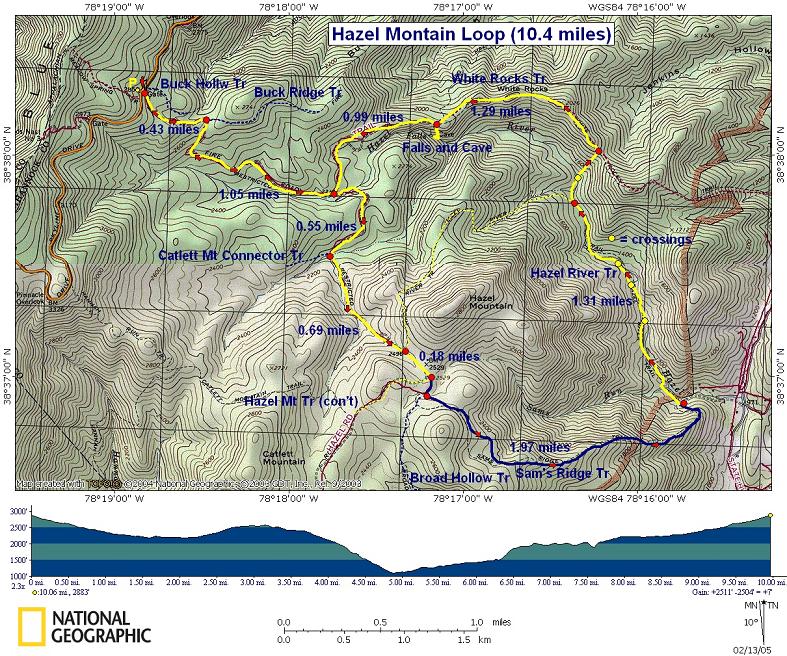
ü This 5 mile out and back hike gently descends the ridge top with its final destination being a cave and waterfall off the White Rocks Trail.
ü The trail head is just after the 33 mile marker on Skyline Drive.
ü The total elevation loss and gain is 800 feet.
ü At the trail head, turn right onto the Hazel Mountain Trail and descend the ridge line 600 feet for 1.6 miles until you reach the trail intersection with the White Rocks Trail. Turn left on to this trail. Follow it as it stays level with the ridge for three-quarters of a mile. The White Rocks Trail then descends 200 feet the last quarter of a mile before you reach a small sign on the right that point to the waterfall and cave.
ü To access the cave and waterfall, follow a steep and long set of stairs down the ridge (150 feet in .2 miles). Both the waterfall and cave are to the right at the bottom of the stairs. Once there, allocate an hour to discover the natural wonders.
ü You can reach the waterfall and cave from the other direction on the White Rocks and Hazel River Trails from the base of SNP on Rt. 600.  Read August 2010 Discovery for Kids.

Age Appropriateness
This hike is best for active children over the age of 6 due to the length, elevation gain and the steepness of the stairs to the waterfall and cave.

What is fun for kids?
ü  Finding and entering the mouth of the cave. The Appalachian Mountains are littered with limestone caves.
ü  Cooling off under the waterfall and in the swimming hole.
ü  Rock scrambling along the Hazel River at the waterfall.
ü  During spring, observe the wildflowers, such as Dutchman's Breeches and Lady Slippers in April and Mountain Laurel in May.
ü  A few unofficial camping sites are across the trail from the cave and waterfall trail head.

Caution
ü  Don't venture too far into the cave. It is best to explore caves with a guide (someone who knows the routes within the cave), a guide line, helmet, head lamp and emergency supplies.
ü  There are no bathrooms at the trail head. The closest ones are 3 miles away at the Thorton Gap entrance station.
ü  There are no trash cans; therefore, trash must be packed out.

Saturday, April 21, 2012

A Bug's Losing Battle


Female Brown-headed cowbird
  During this school year, I have led my middle school students on two nature journaling field trips to our local stream valley park. They journaled about what they observed during the fall and winter drawing connections between the Earth and sun relationship and how temperate climates respond during the seasons. During the field trips, students focused their observations and journaling on the macro, the landscape, because it is more literal to see what is in front of them. On Monday's field trip, I will ask them to observe a small creature for 10 minutes to gain insight on their habits of survival.

    Today, I had my own experience of observing a small animal to learn its relationship in the food web of my backyard. As I was pulling weeds in my vegetable garden, a female, brown-headed cowbird landed next to my rhubarb. My squat become a permanent statue.While removing the lesser celandine that dominate my garden, she drew closer and braver showing no inhibitions to the possibility that I could be a predator.  I could have reached out and grabbed her. My weed peeling revealed many pill bugs. However, she wasn't interested, maybe because they are all crust and no juice. She spotted a brown, quarter-sized spider and snatched it. She struggled with it for a few seconds before she crushed its body and devoured it. There is nothing like the predator prey relationship in nature, no matter how big or small the creatures. It is still fascinating to watch. She is not a carnivore but an omnivore, occasionally feasting on the plentiful helicopters that litter my yard. It is the bugs she preferred though. Saving the best for last, she caught sight of a bug larva. With precision, she plucked the cream-colored larva from the fresh soil. It wiggled to gain its freedom from her beak but lost the battle within milliseconds. Larva to birds are like gummy worms to kids; irresistible sweetness. As I noticed lactic acid build up in my quads, I didn't want to move for fear of missing the show. She occasionally tilted her head to the sky to check for predators, not being afraid that I could be one. After devouring the available protein, it was time for her to fill her tummy elsewhere in my neighborhood. She spread her wings and took off. My matinee performance ended with a smile.

Friday, March 9, 2012

Trail Discovery for Kids: Muddy Branch Trail, Montgomery Co.

Wood Frog

Muddy Branch Trail – River Road to Esworthy Road section
Darnestown, MD

Hike Information
ü  The Muddy Branch Trail is 9 miles long from River Road at Blockhouse Point to Route 28.
ü  The River Road to Esworthy Road section is a 3.4 mile out and back hike.
ü  The trail meanders through park land along the Muddy Branch and up and down the stream valley.
ü  The hike’s gentle elevation gain and lose is 175 feet.
ü  The trail crosses two Muddy Branch tributaries without bridges or stepping stones.
ü  This trail is NOT jogging stroller passable.
ü  Use the Blockhouse parking lot on River Road. The Muddy Branch trailhead is across River Road to the right of the gas pipeline right-of-way.
ü  Link to the trail map.

Age Appropriateness
ü  This hike is best for children six years or older due to the hills and stream crossings.

What is fun for kids?
ü  The trail sits just above the Muddy Branch flood plain which has many vernal pools. Hiking this trail in March and April provides a great opportunity to see and hear many kinds of amphibians. Dawn and dusk are the best times to sit quietly and take in the action.
ü  Multiple opportunities to play in or alongside the Muddy Branch and its tributaries.
ü  About halfway, there is a great spot with some large boulders along the Muddy Branch to sit and have a picnic or a snack.

Caution
ü  Gas pipeline is adjacent to the parkland.
ü  No bathrooms or trash cans; pack-in, pack-out your trash.
ü  Feet may get wet during the two stream crossings.

Tuesday, February 14, 2012

Revitalizing Green Spaces by Building a Trail

Trail head sign

Southern Montgomery County, adjacent to DC, is a densely developed and populated area with patches of green space scattered to provide recreation and respite from the active lives of its citizens. The largest green spaces in the down county are Sligo Creek Park, Northwest Branch Park, and Rock Creek Park; all with trail systems but non connecting to each other; until now.
For two years, multiple organizations (Northwood High School, Potomac Appalachian Trail Club, Chesapeake Bay Trust, Neighbors of Northwest Branch, Friends of Sligo Creek, MD State Highway Administration, Montgomery Parks and Montgomery County Department of Environmental Protection) partnered to build the one and half mile Northwood Chesapeake Bay Trail that connects Sligo Creek and Northwest Branch Parks together. In 2009, the State Highway Administration was persuaded to bank 15 acres of their land for environmental protection. This property is adjacent to Northwood High School. It was used for many years as an unofficial community landfill. With money from the Chesapeake Bay Trust, students and community volunteers removed 11,000 pounds of trash, built a three-quarter mile interpretive trail about the Chesapeake Bay watershed, removed invasive species and planted native trees and plants. This first phase was completed with a National Trails Day celebration in June 2010 with a 5K community fun run and hike.
In April 2011, volunteers constructed more of the trail to University Ave with hopes of extending it further into Breewood Park to reach Sligo Creek Park. As lead organizations, Northwood and the Potomac Appalachian Trail Club worked with Montgomery Parks and Montgomery County Department of Environmental Protection for a year to gain permission and plan the trail extension. In November, 25 students and community volunteers built the half mile extension of the Northwood Chesapeake Bay Trail in Breewood Park.

Anne Ambler of NNWB and Erol Miller of Northwood HS
The Northwood Chesapeake Bay Trail now connects Sligo Creek Park just below University Avenue (on the Parkway across from the last playground) to Northwest Branch Park at the Loxford Terrace connector trail. The trail is blazed in red for Northwood High School. Furthermore, it is posted with a trail sign on Sligo Creek Parkway, University Ave, Northwood High School and in Northwest Branch Park.
The Northwood Chesapeake Bay Trail project is a successful example of a public, private partnership which has left a positive legacy in an urban area with scattered but valuable green space. Montgomery County residents greatly regard their county parks with trails being the most valued resource. This successful public, private partnership protected land for green space and environmental education, restored land to improve the ecosystem’s health including the watershed and built a recreational resource that ties the community to the land creating ownership and pride; creating legacy.

Saturday, November 26, 2011

Be Careful or You'll End Up on Your Butt

After the post Thanksgiving stuffing, my husband, kids, parents and I took a hike on the Appalachian Trail in Maryland to Weaverton Cliffs, north to the Ed Garvey Shelter and back. The leaves are off the trees and ankle deep on the trail. I forgot that freshly fallen leaves are slippery when I almost fell on my butt; however, I managed to catch myself before falling on the edge of a rock. That got me thinking about what are the hazards of hiking after the leaves have just fallen.
  • Hiking on freshly piled leaves is liked walking on a newly polished floor with high heals; the wax provides a perfect opportunity to skid out. The waxy, protective coating on leaves is similar, particularly going down hill. To prevent this, I stepped from rock to rock because of their textured and abrasive surface. Furthermore, while hiking down hill, I took smaller steps and used my quad muscles as brakes.
  • The ankle deep leaves messed with my depth perception and where the best spot was to place my foot on the trail tread. The rocks and tree roots played peekaboo, tricking me with my involuntary decisions to make the right choice.
  • Often times when I hike, I rely on the trail tread to lead me in the right direction and check for blazes at turns and intersections. However, I found myself looking for the white blazes a lot more because the trail tread mimicked the forest floor.
The winter is one of my favorite times of the year to hike because the views are expansive through the woods and the trails are a lot less crowded in the DC area, except for the occasional burst of southwestern air that infiltrates our region in the winter. This causes people to stop hibernating and leave their dens to seek the fresh air of the trail.

Tuesday, September 27, 2011

Camping at Rocky Gap State Park

   Friends in my neighborhood gather every September to go camping for fellowship and fun in nature. For the past nine years, we have camped at a county park, Little Bennett. This park has beautiful nature, great facilities and is a half hours drive from our homes. Camping at this park allows us to participate in our kids weekend sports activities and be close to home for families who are new to camping. Each year, there are the regulars and some families trying camping for the first time. Two thumbs up for them! Sometimes camping for the new families has been successful and they have become regulars but others have packed up in the middle of the night to return home.

   This year on our tenth anniversary, the regulars decided to mix it up and change the location and duration. Instead of one night, we camped the weekend at Rocky Gap State Park. It is a gorgeous park tucked in the mountains of Western Maryland very close to the Pennsylvania border. The park offers an outdoor experience for the novice to the expert: a resort lodge to a campground and mountain bike trails.
I reserved six campsites on Lake Habeeb, each site with their own access and view of the crystal clear lake. We arrived at night to see a mystical fog hover over the lake in the moon light. The kids immediately had a blast exploring the trails to the lake with their flashlights. After hot and humid summer days, we experienced the crispness of fall. Something our bodies were not physically used to. We layered our fleece both morning and night to sit by a campfire and chill while the kids kept warm with a pretend game of Star Wars in the woods - boys against girls! Morning coffee never tasted so good. As the day passed, the sun peeked through the sky providing some warmth. The sun encouraged us adults to move. Some hiked the lake loop while others mountain biked it. To complete my outdoor adventure, I put on my wetsuit for an open water swim in the lake. Refreshing but chilly, as the sun descended over the mountains. As day turned into night, no camping trip is possible without roasting hot dogs and marshmallows over an open fire. Before quiet time descended over the campground, the kids lead us in song from yesterday and today.
   Living in a neighborhood with an "it takes a village" mentally is a true blessing in life; where a sense of community is real and shared by all. The gift is even great when the same sense of community can be shared in nature.

Sunday, August 28, 2011

Trail Discovery for Kids

August Highlighted Hike
Stone Bridge Loop Trail
Manassas Battlefield National Park
Manassas, VA

Hike Information
* 1.1 mile circuit hike on a wide trail with crushed gravel and raised wooden walkways.
* The hike has one moderate hill to ascend and descend, hiking clockwise or counter-clockwise. Each has steps that are widely spaced.
* After the Stone Bridge, turn right or left to start the circuit hike.
* An extra 1/4 of a mile may be added to the hike passed the Van Pelt Site along the field to Bull Run (hiking counter-clockwise).
* Hike both in the woods and open field.
* Trailhead and parking lot on Rt. 29 two miles east of Sudley Rd.
* Trail map.

Age Appropriate
This circuit hike is appropriate for all ages because it is short and jogging stroller passable for toddlers. However, it can be a section of a longer hike for children elementary age and older.

What is fun for kids?
* Easy access to Bull Run to play in the stream or throw rocks.
* Great Civil War interpretive signs of the First Battle of Manassas. Being able to use the natural environment to play act the battle.
* Activities in the Park: Stone House, Henry House, and the museum and movie about the Civil War at the Visitor's Center.

Caution
* No bathrooms at the trailhead/parking lot.